


13704 - CENTER HILL Voting District, Habersham County, Georgia
About
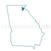
Outline

Summary
| Unique Area Identifier | 562102 |
| Name | 13704 - CENTER HILL Voting District |
| County | Habersham County |
| State | Georgia |
| Area (square miles) | 30.35 |
| Land Area (square miles) | 30.03 |
| Water Area (square miles) | 0.32 |
| % of Land Area | 98.95 |
| % of Water Area | 1.05 |
| Latitude of the Internal Point | 34.53222990 |
| Longtitude of the Internal Point | -83.48312350 |
Maps


Graphs
Select a template below for downloading or customizing gragh for 13704 - CENTER HILL Voting District, Habersham County, Georgia


Neighbors
Neighoring Voting District (by Name) Neighboring Voting District on the Map
- 0110002 - BALDWIN Voting District, Banks County, GA
- 0110005 - COLUMBIA Voting District, Banks County, GA
- 13701 - CLARKESVILLE Voting District, Habersham County, GA
- 13702 - CORNELIA Voting District, Habersham County, GA
- 13703 - DEMOREST Voting District, Habersham County, GA
- 13706 - GLADE CREEK Voting District, Habersham County, GA
- 13709 - BALDWIN Voting District, Habersham County, GA
- 2575 - CURRAHEE Voting District, Stephens County, GA
Top 10 Neighboring County Subdivision (by Population) Neighboring County Subdivision on the Map
- Cornelia CCD, Habersham County, GA (25,565)
- Clarkesville CCD, Habersham County, GA (13,642)
- Toccoa CCD, Stephens County, GA (13,524)
- Martin-Avalon CCD, Stephens County, GA (6,889)
- Baldwin CCD, Banks County, GA (5,208)
Top 10 Neighboring Place (by Population) Neighboring Place on the Map
Top 10 Neighboring Unified School District (by Population) Neighboring Unified School District on the Map
- Habersham County School District, GA (43,041)
- Stephens County School District, GA (26,175)
- Banks County School District, GA (18,395)
Top 10 Neighboring State Legislative District Lower Chamber (by Population) Neighboring State Legislative District Lower Chamber on the Map
Top 10 Neighboring State Legislative District Upper Chamber (by Population) Neighboring State Legislative District Upper Chamber on the Map
Top 10 Neighboring 111th Congressional District (by Population) Neighboring 111th Congressional District on the Map
Top 10 Neighboring Census Tract (by Population) Neighboring Census Tract on the Map
- Census Tract 6.02, Habersham County, GA (8,009)
- Census Tract 5, Habersham County, GA (6,991)
- Census Tract 9701, Stephens County, GA (6,923)
- Census Tract 9704, Stephens County, GA (6,889)
- Census Tract 9701, Banks County, GA (5,208)
- Census Tract 4, Habersham County, GA (4,774)
- Census Tract 3, Habersham County, GA (3,972)
Top 10 Neighboring 5-Digit ZIP Code Tabulation Area (by Population) Neighboring 5-Digit ZIP Code Tabulation Area on the Map
- 30577, GA (22,230)
- 30523, GA (12,904)
- 30531, GA (11,279)
- 30535, GA (7,042)
- 30563, GA (5,373)
- 30511, GA (3,186)